The focus of the paper is to create a spatial risk map for Rift Valley Fever (RVF) using ecological and environmental variables. RVF is a mosquito borne infection in vertebrates. There are typically outbreak of the disease after periods of rainfall and high temperatures. These outbreaks occur in 5 to 15 year intervals with flareups occurring between. Previous studies that have looked at RVF occurrences have not used explicit ecological factors in their models. Here the authors use explicit factors to map the risk of RVF in Kenya. Areas of risk were defined as areas that were able to support the vectors in habitat suitability and population dynamics.
The authors use a generalized linear model to relate the ecological predictors to the occurrence data. For the predictor variables, animal/livestock density, elevation, season length, small vegetation integral, soil ratio, and two principle components of evapotranspiration (PC1_ET and PC2_ET) were used.
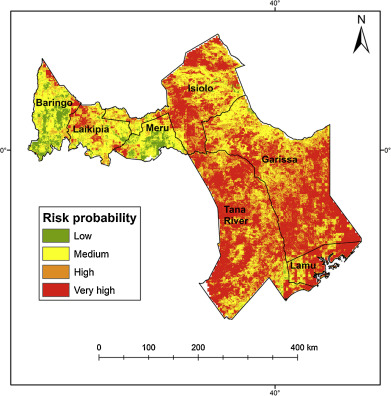
Of the predictors, livestock density, small vegetation integral, and PC2_ET were the most significant variables. In Kenya, the Tana River, Garissa, Isiolo and Lamu were the areas of highest risk. The authors also close by suggesting the integration of livestock movement and density along with the vegetation measurements into early warning systems.
Mosomtai, G., Evander, M., Sandström, P., Ahlm, C., Sang, R., Hassan, O. A., Affognon, H. & Landmann, T. 2016 Association of ecological factors with Rift Valley fever occurrence and mapping of risk zones in Kenya. Int. J. Infect. Dis. 46, 49–55.